
THE STATE OF NEW MEXICO, COMPLAINANT,
vs.
THE STATE OF TEXAS, DEFENDANT.
IN EQUITY.
Return to Dona Ana Main Page
Part One; Part 2; Part three; Part four.

Sponsored by
Genealogy Village
|
|
THE STATE OF NEW MEXICO, COMPLAINANT, vs. THE STATE OF TEXAS, DEFENDANT. IN EQUITY. Return to Dona Ana Main Page Part One; Part 2; Part three; Part four. |
Sponsored by Genealogy Village |
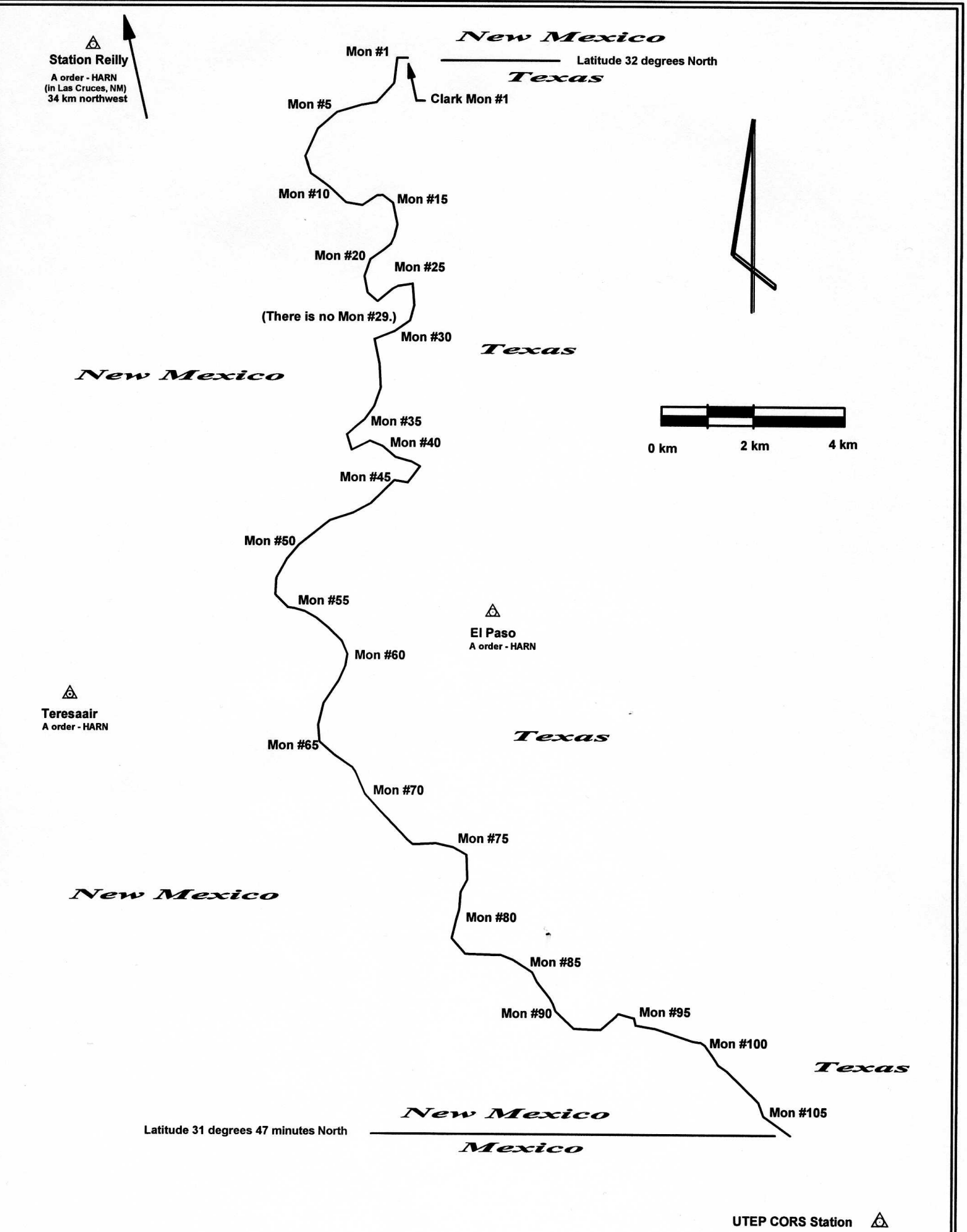
Texas - New Mexico boundry as monumented in 1930.
Supreme Court of the United States
October Term, 1930
No. 2, Original
The State Of New Mexico, Complainant,
Vs.
The State Of Texas, Defendant.
Report of the Boundary Commissioner
Samuel S. Gannett, Commissioner
Washington D.C. July 17, 1930
Page 2
Supreme Court of the United States
October Term, 1930
No. 2, Original
The State Of New Mexico, Complainant,
Vs.
The State Of Texas, Defendant.
Report of the Boundary Commissioner
IN EQUITY.
Contents
Title of accompanying map 3
Section 3 of decree of the Supreme Court dated April 9, 1928
Section V (1) of the Special Master's
report
Method of procedure
Gain and loss of land by New Mexico and Texas by reestablishment of boundary line h,1 1929 and 1930 under the terms of the decree of the Supreme Court 8-9
Descriptions and geographic positions of
triangulation stations.10-19 Dimensions and weight of monuments. 20
Description and geographic position of
Clark Monument No. 1 20-21
Descriptions and ·geographic positions of boundary line and reference
monuments 20-68
Description and geographic position of Kidder Astronomic Monument of 1903 54
Description and geographic position of Gannett Monument No. 1. 21
Total length of boundary line surveyed and monumented in 1929 and 1930
20,79
Number of boundary line and reference monuments 20
Reestablishment of Salazar-Diaz River Traverse of 1852; courses and
distances 69--74
Trial line from Clark Monument No. 1 southwest down east bank of Rio Grande of 1850-1860 to RXIII;
courses and distances, 74
Diagram of same, facing 74
Magnetic declination 75
Description of boundary line by courses and distances 75-79
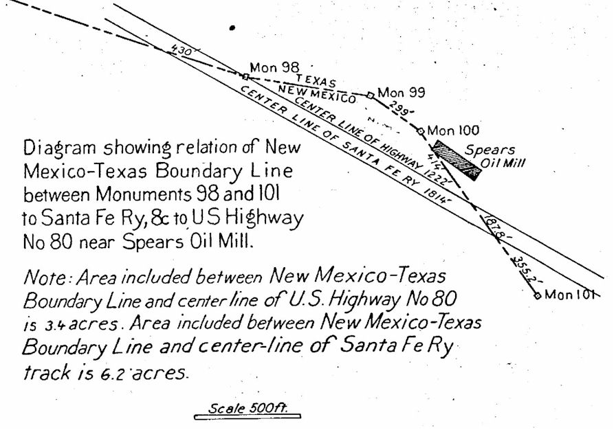
Diagram showing relation of New Mexico-Texas Boundary Line, between
Monuments 98 and 101 to Santa Fe Railway and to
U.S. Highway No. 80 near Spears Oil Mill 9
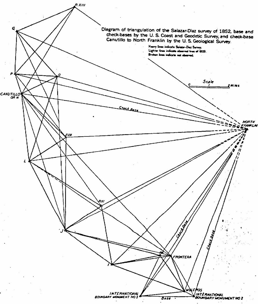
Diagram of triangulation of the Salazar-Diaz Survey of 1852
Bronze tablet imbedded in top of each Boundary Line Monument
Bronze tablet imbedded in top of each Reference Point Monument
Diagram showing New Mexico-Texas Boundary Line In drainage ainal from Boundary Monument 71 to Boundary Monument 72 and near Reference Monuments 32 and 33.
38-39
Diagram showing New Mexico-Texas Boundary Line ln Rio Grande of 1930
near Boundary Monuments 81 and 82 and near Reference Monuments
29 and 30 42-43
Diagram showing connection made ln 1929 and 1930 by the New
Mexico-Texas Boundary Commission between Clark Monument No. 1 as reestablished
by the Scott-Cockrell Commission of 1911 and triangulation station RXIII of the
Salazar-Diaz Survey of 1852. 74-75
Map of the Boundary Line between New Mexico and Texas in the Valley of
the Rio Grande from the Parallel of 32 degrees north latitude, southwardly to
the parallel of 31 degrees and 47 minutes as surveyed ln
1929 and 1930, 78-79
Supreme Court of the United States
October Term, 1930
No. 2, Original
The State Of New Mexico, Complainant,
Vs.
The State Of Texas, Defendant.
Report of Commissioner Appointed To Run, Locate, and Mark the Boundary
Between New Mexico and Texas.
To the Honorable Chief Justice and the Associate Justices of the
Supreme Court of the United States: I, Samuel
S. Gannett, Washington, D. C., Commissioner appointed under decree of
the Court rendered April 9, 1928, to run, locate, and mark the boundary between the State of New Mexico and the State of Texas in the valley of the Rio
Grande River, extending southwardly from the parallel of 3'J degrees north latitude to the parallel of 31 degrees 47 minutes on the international boundary between the United States of America and the United States of Mexico, have the honor to submit the following report with an accompanying In:RP· The map is marked as follows:
1-No. 2, Orig.
3
Supreme Court of the United States
October Term, 1930
No. 2, Original
The State Of New Mexico, Complainant,
Vs.
The State Of Texas, Defendant.
Map of the Boundary line between New Mexico and Texas
in the Valley of the Rio Grande River from the parallel of 32 degrees north
latitude southwardly to the parallel of 31 degrees and 47 Minutes, as surveyed in 1929 and 1930, in accordance
with the terms of the above-entitled cause.
Section 3 of the decree specifies as follows:
''The true boundary between the State of New Mexico and the State of
Texas in the valley of the Rio Grande River, extending southwardly from the
parallel of 82 degrees north latitude to the parallel of 31 degrees 47 minutes
on the international boundary between the United
States of America and the United States of Mexico, is the middle of the channel
of the Rio Grande River as it existed on the 9th day of ·September, 1850, as
outlined by the special master in Section V (1) of his report ; the intersection of the east bank of the river with the line of the 32nd parallel to be
taken at a point 600 feet west from the Clark Monument No. 1 as re-established
by the Scott-Cockrell Commission, and the middle line of the channel to be taken
150 feet from the east and west banks of the river, respectively, as found by
the special master."
4
Sec. V (1) of the special master's report referred to in section 3 of
the decree follows:
"Conclusions as to the location, course, and width of the Rio Grande in 1850
(1) Course and Location
"On all the evidence in the case, I find
that the allegations in the plaintiff's bill of complaint, as to the location and course of the Rio Grande,
''as it existed in the year 1850,'' are not sustained, and that the river did
not flow on the eastern side of the valley as set forth in the plaintiff 's '
Pleading Map.
I find the location and course of the Rio Grande ''as it existed in the
year 1850'' to have been, in general, as alleged in the defendant 's cross bill,
and, in particular, as follows, on the dates nearest to 1850 of which there is
credible evidence.
The earliest date at which there is definite evidence
of the location and course of the river at the thirty second parallel is
January, 1859, when John H. Clark made his survey of the parallel, at which time
he located his Monument No. 1, 600 feet east of the east bank of the river. In
August, 1860, Anson Mills made his Texas Surveys No. 161 and 162, at which time
the east bank of the river was only 428 feet (154 varas) west of Monument No. 1, the river
hang, shifted to the eastward 172 feet, between January, 1859 and August, 1860.1
I find that the location of the east bank and of the course of the
river of 1850, from the thirty second parallel to a point a few
hundred feet northeast of the northernmost point on the Salazar-Diaz Survey of
1852, was its location and course shown on the plats and field notes of Texas
Surveys No. 161 and 162.
1. See Surveys No. 161 and No. 162 and Resurvey of No. 162, Defendant's Exhibits No. 16, 16a, 17, 17a, Record
3223-3228.
5
Between the extreme southwestern corner of Survey No. 162 and the northernmost point of the Salazar-Diaz Survey,
there is a gap of a few hundred feet. The location of the east bank and the
course of the river for this gap, I find was that shown on the plat and field
notes of Texas Survey No. 85, a survey made on October 4, 1849.2
The location of the west bank and of the course of the river, in
1852, from the northernmost point of the SalazarDiaz Survey to the point called Frontera and thence to the Canyon, I find was that shown by the triangulation, traverse, and field notes contained in the Salazar-Diaz Survey (substantially as reproduced on Defendant 's Exhibit No. 70, Record 3373, subject to any necessary corrections on that reproduction as to the proper magnetic
variations).
The location and course of the river through the Canyon, in 1850, find was
the same as its location in 1913 (the date when the bill of complaint was
filed).
The location of the west bank and of the course of the river, in 1852, from the southern end of the Canyon to the
International Boundary Line, viz., to the parallel of 31
degrees 47 minutes north latitude, ·I find was that shown by the Salazar-Diaz Survey.''
Method of Procedure
Field work of running, locating, and marking the boundary
line was begun in August, 1929 and completed in February, 1930.
(1) A transit traverse line was carefully run around that portion of the Rio Grande Valley in which the disputed boundary line
is situated, as a base for a topographic map of the area of 60 square miles, and
to furnish a check upon other transit traverse lines which were later run to
determine the exact positions of all boundary and reference monuments.
2. Defendant's Exhibit No. 15, Record 3222, red numbered pages
5487-5490.
6
(2) The Salazar-Diaz triangulation and traverse of 1852 were
reproduced on the ground as closely as possible, from the angles, bearings, and
distances given in the record. The triangulation stations having originally been
more carefully located, their positions were accepted as being correct and the
traverse lines were adjusted to fit.
(3) Using the adjusted Salazar-Diaz traverse along the west bank
of the Rio Grande of 1852 as a reference line, sites for
monuments were selected at the proper distance at angle points to the eastward so that the resulting final boundary line along the middle of the river would be parallel to and 150 feet to the eastward of the line originally run in 1852 on the west bank of the river. Fortunately these sites are, in nearly all instances, on dry
soil, furnishing a stable foundation for the monuments.
(4) After the erection of substantial concrete boundary line
monuments at angle points, determined by the method indicated in the preceding
paragraph, the true course and distance between adjacent monuments as well as
the elevation of top of each monument, was very carefully determined.
Of the natural objects mentioned in the record as having been used by
the Salazar-Diaz Survey of 1852, Muleros, a well own mountain with a definite
sharp summit, rising nearly 1,000 feet above the surface of water in the river,
was most easily and surely identified from Special Masters Exhibit No. 1. (The Emory Map of 1855.)
With Muleros as the initial point, the position of Frontera astronomical station, as accepted and marked upon the ground by engineers for the plaintiff and for the
defendant was verified by the true course and distance from Muleros, namely N. 21° 34' 30'' W, 2,974.93 meters or 9,760.25 feet. (Defendant's Exhibit No. 70.)
Using the line Frontera Muleros as a base, the other triangulation stations RX, I, RXI, J, L, RXII, N, O, P, Q,
and RXIII were located on the ground from the angles and distances of Salazar and Diaz given on pages
2386-2388 of the Record.
7
Triangulation stations P and Q were consider as having been closely identified on the ground. Each of these stations
being located on a definite ridge or mesa point on the western edge of the Rio
Grande Valley and more than 300 feet above the river. These two mesa points
although considerably eroded by wind and rain since first established in 1852
have apparently not changed much in appearance since that date. The points
adopted and marked for triangulation stations P and Q, in 1929, may therefore be
considered as located within a very few feet of the original Salazar-Diaz stations and serve as a check on locations
adopted for Muleros, Frontera, and all other
triangulation and traverse stations of the Salazar-Diaz Survey of 1852.
Stations· I, J, L, and N, which are likewise situated on the mesa bluff
on the. west side of the valley are in each case on comparatively level, sandy
summits whose appearance has undoubtedly been greatly changed by wind storms
since :first located in 1852. These stations as well as stations 0, RX, RXI,
RXII, and RXIII were established in 1929 as nearly as possible from the angles
and distances given in the record.
They are all located in the comparatively level valley with no natural
features to help in their identifications.
The triangulation and transit traverse along or near the
New Mexico-Texas boundary in the Rio Grande Valley was connected with the
first-order triangulation net of the United States through stations
Canutillo, North Franklin, International Boundary Monuments Nos. 1, 2, and 3, by
the New Mexico-Texas Boundary Commission in 1929 and 1930 and consequently the
geographic positions of all stations as well as positions of
all boundary and reference monuments have been computed on the North American datum of 1927.
The instrumental work of 1929 and 1930 along the disputed New
Mexico-Texas boundary line in the valley of the Rio Grande was done by E. L.
McNair, geodetic engineer, chief of field party, for more than 30 years an
employee of the United States Department of the Interior Geological
8
Survey. Mr. McNair was also chief of field
party in the survey and monumenting of the 100th Meridian boundary
between Oklahoma and Texas, as noted in report of the commissioner for the
Supreme Court of the United States, October term 1929 No. 6, Original, The State
of Oklahoma, Complainant, vs. the State of Texas,
Defendant, the United States of America, Intervener.
Angles in the triangulation were measured with a theodolite having a
circle 8 inches in diameter reading by two micrometers to 2 seconds of arc. The
closure error of 29 triangles in the scheme is 3.2".
Angles at stations along the traverse lines were measured at least four
times with a transit having a circle 6½ inches in diameter, reading by 2
verniers to 30'' of arc. Observations to determine the
true meridian were made on Polaris at intervals not exceeding 3
miles.
Distances were measured with a steel tape 300 feet in length under a
tension of 20 lbs. the temperature was observed at frequent intervals, and the
necessary correction was applied to reduce to the standard temperature of 68°.
An invar tape 300 feet in length was available as a standard of
comparison and the 300 foot steel tape was tested with it every few days.
Distances were also reduced to mean sea level so that the geodetic
positions of all stations and monuments could be computed.
The boundary line between New Mexico and Texas in the Rio Grande
Valley, established in 1929 and 1930 in compliance with terms of the
decree of the Supreme Court of the United States dated April 9, 1928, and described in this report, will
cause the net loss of approximately, 2496 acres or 3.9 square miles by
Texas to New Mexico, as follows:
|
Texas
|
Acres
|
|
Patented land actually lost
|
2,500
|
|
Doubtful patented area by Texas sold by Texas claimants as
Texas land
|
370
|
|
|
2,870
|
|
Land gained from New Mexico
|
374
|
|
New loss by Texas
|
2,496
|
|
New Mexico
|
Acres
|
|
Patented Texas land gained by New Mexico |
2,500 |
|
Doubtful patented Texas Land actually sold by Texas claimants
|
370
|
|
|
2,870
|
|
Land lost by New Mexico
|
374
|
|
New gain by New Mexico
|
2,496
|
The area gained by New Mexico near El Paso Power Co.'s Plant and near Spears Oil Mill and situated to
the northeast of the Santa Fe Railway right-of-way is approximately 6.2 acres
including 3.4 acres immediately northeast of U. S. highway No. 80. Twelve hundred and twenty-two feet of U. S. highway No. 80, southeast from
Boundary Monument 98 and 1814 feet of the Santa Fe Ry. track in the same
locality are in New Mexico and not in Texas as commonly believed.
10
The Field Notes Of The Boundary Survey And Of Triangulation And Transit
Traverse, Together With Tabulations Of Technical Data Follow:
Descriptions and Geographic Positions on 1927 North American Datum of
Triangulation Stations of the United States Coast and Geodetic
Survey, The United States Geological Survey, and of the Salazar-Diaz Survey of 1852 as reestablished by the New
Mexico-Texas Boundary Line Commission in 1929 and 1930.
International Boundary Monument No. 1 of United States-Mexico 1855
On the west bank of the Rio Grande, 635.8 feet due west from Reference
Monument No. 17 which is on east bank of river. It is 483.39 feet due west from
the terminal point of the New Mexico-Texas boundary, which point falls in the
river (of 1930). No triangulation stations visible. Station mark: A cut stone
monument 12 feet high, 5 feet square at base and 2½ feet square at top.
It is encased in covering of concrete and painted white, an iron picket fence
surrounds the monument for protection.
[Latitude 31° 47' 01.606". Longitude 106° 31' 45.109".]
|
|
|
|
Distance
|
|
|
To Station
|
Azimuth
|
Back Azimuth
|
At Sea Level, Log meters
|
Feet, Surface
|
|
Inter Bdy Mon. No. 3
|
90 00 47.2
|
269 59 21.9
|
3.629704
|
13988.3
|
|
Muleros
|
114 14 34
|
294 14 17
|
2.955775
|
2963.7
|
|
North Franklin
|
197 21 44
|
17 23 06
|
4.140800
|
45379.8
|
(No Page Number)
11
International Boundary Monument No. 2 of 1855
This is a station of the U. S. Coast and Geodetic Survey of 1893 which
is 32 feet S. 30° E. true from Boundary Monument No. 2. It is on top of a high
ridge west of the Rio Grande
Station mark: A bronze tablet of the U. S. Coast and Geodetic Survey
cemented in solid rock.
[Latitude 31° 47’ 01.332”. Longitude 106° 32’ 11.978”]
|
|
|
|
Distance
|
|
|
To Station
|
Azimuth
|
Back Azimuth
|
At Sea Level, Log meters
|
Feet, Surface
|
|
Inter Bdy Mon. No. 3
|
90 07 34.8
|
270 06 09.4
|
3.630204
|
14004.4
|
|
Muleros
|
114 36 03.7
|
294 35 47.1
|
2.959559
|
2989.7
|
|
Fronteras
|
148 34 26.3
|
328 33 47.8
|
3.568751
|
12100.8
|
|
North Franklin
|
197 19 56.8
|
17 21 19.6
|
4.141006
|
45401.2
|
North Franklin, El Paso County, Texas (Not occupied)
Situated on the highest peak of the Franklin Mountains about 11 miles
due north from El Paso and 6.5 miles a little
12
South east from Canutillo. It may be approached from either side
with an approximate climb of 3,000 feet in each case
[Latitude 31° 54’ 10.122”. Longitude 106° 26’ 35.111”.]
|
|
|
|
Distance
|
|
|
To Station
|
Azimuth
|
Back Azimuth
|
At Sea Level, Log meters
|
Feet, Surface
|
|
Inter Bdy Mon. No. 2 Eccentric
|
17 21 19.6
|
197 19 56.8
|
4.141006
|
45401.2
|
|
Muleros
|
21 07 26.5
|
201 05 47.1
|
4.138313
|
45120.6
|
|
Fronteras
|
81 01 14.9
|
210 59 13.6
|
4.069560
|
38514.3
|
|
Inter. Bdy. Mon. No. 3
|
32 27 57.4
|
212 25 09.1
|
4.194210
|
51318.3
|
|
RX
|
34 42 20
|
214 40 00
|
4.085763
|
89978.4
|
|
Station I
|
44 46 20
|
224 42 45
|
4.181639
|
49853.4
|
|
Station J
|
60 42 13
|
240 37 23
|
43220642
|
54538.6
|
|
RX I
|
60 54 17
|
241 50 24
|
4.118040
|
43062.8
|
|
Station L
|
80 56 40
|
260 50 53
|
4.244019
|
57554.8
|
|
RX II
|
86 32 35
|
266 27 44
|
4.161032
|
47543.8
|
|
Canutillo
|
97 51 24.54
|
277 45 22.83
|
4.4597468
|
59540.0
|
|
Station P
|
102 16 35
|
282 10 22
|
4.277797
|
62209.8
|
|
Station O
|
104 19 35
|
284 14 30
|
4.193704
|
51258.5
|
|
Station Q
|
111 47 19
|
391 41 06
|
4.296243
|
64909.0
|
|
RX III
|
124 06 12
|
304 01 34
|
4.221550
|
54652.8
|
Frontera, El Paso County, Texas
This is a reestablished triangulation station, of the Salazar-Diaz
Survey of 1852 and an astronomic station of Major W. H. Emory of the same
year. It is 163 feet south and 98 feet east of Gibsons Crossing of Santa Fe Railway, 32 feet southwest of center of railway track and 1.8 feet lower than top of rail.
Station mark: A bronze tablet set in concrete block 20 inches square
and 2 inches deep, with top 3 inches above surface of ground. It is stamped
"Reference Point No. 8. Frontera".
13
[Latitude 31° 48' 43.494". Longitude 106° 33' 25.081".)
|
|
|
|
Distance
|
|
|
To Station
|
Azimuth
|
Back Azimuth
|
At Sea Level, Log meters
|
Feet, Surface
|
|
Inter Bdy Mon. No. 3 Eccentric
|
86 45 58.5
|
216 45 11.6
|
3.592942
|
12853.0
|
|
Station I
|
81 05 15
|
261 03 41
|
3.672778
|
15446.9
|
|
RX
|
92 44 10
|
272 43 50
|
2.948923
|
2917.3
|
|
Station J
|
102 48 31
|
282 45 42
|
3.937630
|
28424.4
|
|
Station L
|
122 53 12
|
302 49 82
|
4.128030
|
44064.8
|
|
Canutillo
|
136 24 07
|
316 20 07
|
4.238154
|
56782.7
|
|
North Franklin
|
210 59 13.6
|
81 01 14.9
|
4.069560
|
88514.3
|
|
Inter. Bdy. Mon No. 2 Ecc
|
328 33 48
|
148 84 26
|
3.566751
|
12100.8
|
|
Muleros
|
338 24 49
|
158 25 11
|
3.473629
|
9165.4
|
|
Reference Mon, No. 25
|
356 16 39
|
176 16 43
|
3.225410
|
5514.1
|
Muleros, Dona Ana County, New Mexico
This is a station of the Salazar-Diaz Survey of 1852. It is about 1,220
feet north of International Boundary line and 2,700 feet west of International
Boundary Monument No. 2. It is on the highest peak of Muleros
Mountain.
Station mark: A bronze tablet stamped "Muleros" set in solid rock.
Reference mark: A bronze tablet set in solid rock, 12.79 feet distant,
in azimuth 291° 50' from the station mark.
[Latitude 31° 47' 13.644". Longitude 106° 32' 43.476".]
|
|
|
|
Distance
|
|
|
To Station
|
Azimuth
|
Back Azimuth
|
At Sea Level, Log meters
|
Feet, Surface
|
|
Inter Bdy Mon. No. 3
|
83 51 26.8
|
263 50 17.9
|
3.538980
|
11851.2
|
|
Station I
|
109 31 55
|
289 80 00
|
3.785053
|
20003.9
|
|
Station J
|
116 10 05
|
296 06 55
|
4.026564
|
34884.0
|
|
Station L
|
129 07 00
|
309 03 00
|
4.202622
|
52322.0
|
|
RX I
|
135 04 35
|
315 02 80
|
3.972240
|
30782.4
|
|
RX II
|
141 28 80
|
821 25 21
|
4.183891
|
50113.3
|
|
RX
|
144 47 35
|
324 46 56
|
3.536426
|
11284.6
|
|
RXIII
|
158 14 14
|
338 11 21
|
4.377663
|
78293.4
|
|
Frontera
|
158 25 11
|
338 24 49
|
3.473629
|
9765.4
|
|
N. Franklin
|
201 05 47.1
|
21 07 26.5
|
4.138313
|
45120.6
|
|
Inter Bdy Mon. No. 2 Ecc.
|
294 85 47
|
114 36 04
|
2.959559
|
2989.7
|
14
Rx, Dona Ana County, New Mexico
This is a station of the Salazar-Diaz Survey of 1852. It is 0.55 mile
west of Gibson's Crossing of Santa Fe Railway in cultivated field on land of T.
D. Porcher.
Station mark: Standard concrete monument with bronze tablet stamped
"Reference Point No. 45. RX".
[Latitude 31° 48' 44.87". Longitude 106° 33' 58.85".]
|
|
|
|
Distance
|
|
|
To Station
|
Azimuth
|
Back Azimuth
|
At Sea Level, Log meters
|
Feet, Surface
|
|
Inter Bdy Mon. No. 3
|
24 86 04
|
204 85 85
|
3.543798
|
11477.8
|
|
Station I
|
78 24 07
|
258 22 63
|
3.584510
|
12605.8
|
|
Station J
|
103 56 48
|
283 54 18
|
3.891518
|
25561.1
|
|
N. Franklin
|
214 40 00
|
84 42 20
|
4.085763
|
39978.4
|
|
Frontera
|
272 43 50
|
92 44 10
|
2.948923
|
2917.3
|
|
Muleros
|
824 46 56
|
144 47 35
|
3.536426
|
11284.6
|
RXI, Dona Ana County, New Mexico
This is a station of the Diaz-Salazar Survey of 1852. It is 320 feet north and 8,160 feet west of highway bridge across Rio Grande
west of the Country Club, 390 feet west of bridge across drainage ditch, 160
feet north of highway in cultivated field on land of S. N. Russell.
Station mark: A standard concrete monument with bronze tablet in top
stamped ''Reference Point No. 45. RXI.''
[Latitude 31° 50' 49.25". Longitude 106° 36' 55.42".]
|
|
|
|
Distance
|
|
|
To Station
|
Azimuth
|
Back Azimuth
|
At Sea Level, Log meters
|
Feet, Surface
|
|
Station J
|
58 08 26
|
238 07 27
|
3.545408
|
11520.5
|
|
Station L
|
120 42 19
|
300 40 23
|
3.825067
|
21934.6
|
|
Canutillo
|
143 28 48
|
323 26 37
|
4.032107
|
35332.1
|
|
N. Franklin
|
241 50 24
|
61 54 17
|
4.118040
|
43062.8
|
|
Muleros
|
815 02 80
|
135 04 35
|
3.972240
|
30782.4
|
|
I
|
349 09 05
|
169 09 23
|
3.670930
|
15381.3
|
RXII, Dona Ana County, New Mexico
A station of the Salazar-Diaz Survey of 1852. It is 0.6 mile
north of Borderland road, 2,200 feet west of a north-
15
south road in cultivated field on land now owned by J. N. Duke, from L.
M. Crawford Survey.
Station mark: A standard concrete monument with bronze tablet stamped
"RXII Reference Point No. 43".
[Latitude 31° 53' 41.42". Longitude 106° 38' 45.45".]
|
|
|
|
Distance
|
|
|
To Station
|
Azimuth
|
Back Azimuth
|
At Sea Level, Log meters
|
Feet, Surface
|
|
Station J
|
0 10 22
|
180 10 21
|
3.860909
|
29821.6
|
|
Station L
|
56 29 56
|
236 28 59
|
3.534680
|
11239.4
|
|
Canutillo
|
133 25 46
|
313 34 38
|
3.686364
|
15937.7
|
|
Station P
|
140 16 58
|
320 15 29
|
3.958930
|
29853.3
|
|
Station Q
|
154 29 38
|
334 28 19
|
3.958930
|
29853.3
|
|
N. Franklin
|
266 27 44
|
88 32 35
|
4.161032
|
47543.8
|
|
Muleros
|
321 25 21
|
141 28 30
|
4.183891
|
50113.3
|
RXIII, Dona Ana County, New Mexico
This is the most northerly station of the Salazar-Diaz Survey of 1852.
It is approximately 2.0 miles west of Anthony, New Mexico, about 640
feet north of an east-west road and nearly north from a bridge crossing
irrigating canal. It is on land of Margaret Rowley.
Station mark: Standard concrete monument with bronze tablet stamped
"RXIII Reference Point No. 42".
[Latitude 31° 59' 13.00”. Longitude 106° 38' 20.43".]
|
|
|
|
Distance
|
|
|
To Station
|
Azimuth
|
Back Azimuth
|
At Sea Level, Log meters
|
Feet, Surface
|
|
Canutillo
|
31 18 26
|
211 17 02
|
3.904890
|
26360.4
|
|
Station P
|
41 39 12
|
221 37 36
|
3.851974
|
23336.5
|
|
Station Q
|
66 21 33
|
246 20 01
|
3.698378
|
16384.7
|
|
N. Franklin
|
304 01 34
|
124 06 12
|
4.221550
|
64652.8
|
|
Muleros
|
338 11 21
|
158 14 14
|
4.377663
|
78293.4
|
Station I, Dona Ana County, New Mexico
This is a station of the Salazar-Diaz Survey of 1852. Situated about
3.5 miles nearly due west from El Paso Power Company's plant, on top of mesa on
sandy promontory.
16
There are small sand dunes of changing form and clusters of greasewood.
Station mark: An iron pipe 4 feet long driven 3 feet into the sand.
[Latitude 31° 48' 19.77". Longitude 106° 36' 21.89".]
|
|
|
|
Distance
|
|
|
To Station
|
Azimuth
|
Back Azimuth
|
At Sea Level, Log meters
|
Feet, Surface
|
|
Station J
|
124 53 20
|
304 52 03
|
3.665560
|
15192.2
|
|
Station L
|
140 24 50
|
320 22 45
|
4.017180
|
34138.3
|
|
Station RXI
|
169 09 23
|
349 09 05
|
3.670930
|
15381.3
|
|
N. Franklin
|
224 42 45
|
44 46 20
|
4.181633
|
49853.4
|
|
RX
|
258 22 53
|
78 24 07
|
3.584510
|
12605.8
|
|
Frontera
|
261 03 40
|
81 05 15
|
3.672778
|
15446.9
|
|
Muleros
|
289 30 00
|
109 31 55
|
3.785053
|
20003.9
|
STATION J, Dona Ana County, New Mexico
This is a station of the Salazar-Diaz Survey of 1852. Situated 4.2
miles west and 1,950 feet south of forks of high way at White's Spur, Santa Fe
Railway. It is on top of mesa on a conspicuous promontory around which
passes the Southern Pacific Company railroad on the east and north making a deep
cut through the point of promontory. Station is several hundred feet back from
the railroad on practically the highest ground in immediate vicinity. Land
is very sandy with clusters of greasewood.
Station mark: An iron pipe 4 feet long driven 3 feet in the sand.
[Latitude 31° 49' 45.73". Longitude 106° 38' 46.28".]
|
|
|
|
Distance
|
|
|
To Station
|
Azimuth
|
Back Azimuth
|
At Sea Level, Log meters
|
Feet, Surface
|
|
Station L
|
152 10 09
|
332 09 13
|
3.783262
|
19921.6
|
|
Canutillo
|
161 45 50
|
341 44 40
|
4.048027
|
36651.3
|
|
RXII
|
180 10 21
|
0 10 22
|
3.860909
|
23821.06
|
|
RXI
|
236 07 27
|
56 08 26
|
3.545408
|
11520.5
|
|
North Franklin
|
240 37 23
|
60 42 13
|
4.220642
|
54538.6
|
|
Frontera
|
282 45 42
|
102 48 31
|
3.937630
|
28424.4
|
|
RX
|
283 54 18
|
103 56 48
|
3.891518
|
25561.1
|
|
Muleros
|
296 06 55
|
116 10 05
|
4.026564
|
34884.0
|
|
I
|
304 52 03
|
124 53 20
|
6.665560
|
15192.2
|
|
International Bdy. Mon. 3
|
309 38 ..
|
.. .. ..
|
…………
|
………..
|
17
Station L, Dona Ana. County, New Mexico
This is a station of the Salazar-Diaz Survey of 1852. Situated on a
conspicuous promontory about 0.9 mile south of Borderland road and about 4.6 miles west of Montoya. It is
on top of mesa on very sandy land with clusters of greasewood.
It can be reached by driving west on Borderland road taking a second
class left hand fork after leaving the valley lands. This road passes to the
south of the promontory which can be reached by a short walk.
Station mark: An iron pipe 4 feet long driven 3 feet in the sand.
[Latitude 31° 52' 40.02''. Longitude 106° 40' 34.12''.]
|
|
|
|
Distance
|
|
|
To Station
|
Azimuth
|
Back Azimuth
|
At Sea Level, Log meters
|
Feet, Surface
|
|
Canutillo
|
172 47 29
|
358 47 15
|
3.722747
|
17330.4
|
|
RXII
|
236 28 59
|
56 29 56
|
3.534680
|
11239.4
|
|
North Franklin
|
260 50 53
|
80 56 42
|
4.244019
|
57534.8
|
|
RXI
|
300 40 23
|
120 42 10
|
3.825087
|
21934.6
|
|
Frontera
|
302 49 32
|
122 53 12
|
4.128030
|
44064.8
|
|
Muleros
|
309 03 00
|
129 07 00
|
4.202622
|
52322.0
|
|
Station I
|
320 22 45
|
140 24 50
|
4.017180
|
34138.3
|
|
Station J
|
152 10 09
|
152 10 09
|
3.783262
|
19921.6
|
Station N or Canutillo, Dona Ana County, New Mexico
This station corresponds with station N of the Salazar-Diaz Survey of
1852 and is also a station of the U. S. Geo logical Survey of 1917. About 0.85
mile north and 4.8 miles west of Canutillo, Texas. It is on top of mesa at a
point where a long narrow ridge projects farthest east into sand hill. The
bluffs are quite-precipitous on the south, east, and north. It may be reached by
car by takin g road west from La Union to top of mesa, then turning south and
following rim of mesa to the station.
Station mark: A concrete post 2 feet long, 7 inches square at bottom, 5 inches at top, set about 22 inches in ground and bronze tablet of U. S. Geological Survey in top.
2-No. 2, Orig.
18
[Latitude 31° 55' 30.136". Longitude 106° 40' 59.324".]
|
|
|
|
Distance
|
|
|
To Station
|
Azimuth
|
Back Azimuth
|
At Sea Level, Log meters
|
Feet, Surface
|
|
Station P
|
160 21 44
|
340 21 33
|
3.216274
|
5399.3
|
|
Station Q
|
175 16 33
|
355 16 25
|
3.688230
|
16006.4
|
|
Station RXIII
|
211 17 02
|
31 18 26
|
3.904890
|
26360.4
|
|
N. Franklin
|
277 45 23.82
|
97 51 24.54
|
4.258747
|
59540.0
|
|
Station RXII
|
313 34 38
|
133 35 49
|
3.686364
|
15937.7
|
|
Frontera
|
316 20 07
|
136 24 07
|
4.238154
|
58782.7
|
|
Station RXI
|
328 26 37
|
143 28 46
|
4.032107
|
35332.1
|
|
Station J
|
341 44 40
|
161 45 50
|
4.048027
|
36651.3
|
|
Station L
|
352 47 15
|
172 47 29
|
3.722747
|
17330.4
|
Station O, Dona Ana County, New Mexico
La Union, about 0.94 mile south and 0.45 mile east of Station O of the
Salazar-Diaz Survey of 1852 would be to the west of this point but its
visibility with stations L, N, P, and Q, would be cut off by grove of trees
around farm house and its closeness to waste bank of drainage ditch, hence a
position farther to the east was used. It is in a cultivated field.
Station mark: None.
[Latitude 31° 56' 15.25". Longitude 106° 39' 11.33".]
|
|
|
|
Distance
|
|
|
To Station
|
Azimuth
|
Back Azimuth
|
At Sea Level, Log meters
|
Feet, Surface
|
|
Canutillo
|
63 54 45
|
243 53 48
|
3.499544
|
10365.9
|
|
Station P
|
93 43 03
|
272 41 54
|
3.530615
|
11134.7
|
|
Station Q
|
137 00 33
|
316 59 27
|
3.676470
|
15578.7
|
|
North Franklin
|
284 14 30
|
104 19 35
|
4.193704
|
51258.5
|
Station P, Dona Ana County, New Mexico
A station of the Salazar-Diaz Survey of 1852. La Union Crossroads, 0.8
mile south and 1.65 miles west of on top of mesa, on a projecting
ridge.
A second-class road leads west from La Union. Stop just before road
begins to climb mesa and walk southward following a ridge about 900 feet to the
station.
Station mark: A concrete block of about 15 inches cubic dimensions in
which is placed a copper bolt.